Back Tibèt ACE Outonome Gewes Tibet Afrikaans منطقة التبت ذاتية الحكم Arabic তিব্বত স্বায়ত্তশাসিত অঞ্চল Assamese Rexón Autónoma del Tíbet AST Tibet Muxtar Vilayəti Azerbaijani Tibet BAR Awtonomong Rehiyon kan Tibet BCL Тыбецкі аўтаномны раён Byelorussian Тыбэцкі аўтаномны раён BE-X-OLD
Tibet Autonomous Region | |
|---|---|
| Chinese transcription(s) | |
| • Simplified Chinese | 西藏自治区 |
| • Hanyu pinyin | Xīzàng Zìzhìqū |
| • Abbreviation | XZ / 藏 (Zàng) |
| Tibetan transcription(s) | |
| • Tibetan script | བོད་རང་སྐྱོང་ལྗོངས། |
| • Tibetan pinyin | Poi Ranggyong Jong |
| • Wylie translit. | bod rang skyong ljongs |
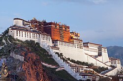
 The Potala Palace in Lhasa | |
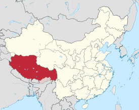
 Location of the Tibet Autonomous Region in China (territory claimed by China but controlled by India is striped) | |
| Country | China |
| Capital and largest city | Lhasa |
| Divisions - Prefecture-level - County-level - Township- level | 7 prefectures 74 counties 699 towns and subdistricts |
| Government | |
| • Type | Autonomous region |
| • Body | Tibet Autonomous Region People's Congress |
| • CCP Secretary | Wang Junzheng |
| • Congress Chairman | Losang Jamcan |
| • Government Chairman | Yan Jinhai |
| • Regional CPPCC Chairman | Pagbalha Geleg Namgyai |
| • National People's Congress Representation | 24 deputies |
| Area | |
| • Total | 1,228,400 km2 (474,300 sq mi) |
| • Rank | 2nd |
| Highest elevation | 8,848 m (29,029 ft) |
| Population (2020[2]) | |
| • Total | 3,648,100 |
| • Rank | 32nd |
| • Density | 3.0/km2 (7.7/sq mi) |
| • Rank | 33rd |
| Demographics | |
| • Ethnic composition | 86.0% Tibetan 12.2% Han 0.8% others |
| • Languages and dialects | Tibetan, Mandarin Chinese |
| GDP[3] | |
| • Total | CN¥ 213 billion US$ 32 billion |
| • Per capita | CN¥ 58,438 US$ 8,688 |
| ISO 3166 code | CN-XZ |
| HDI (2021) | |
| Website | www |
The Tibet Autonomous Region, officially the Xizang Autonomous Region, often shortened to Tibet or Xizang,[note 1] is an autonomous region of China and is part of Southwestern China.
It was formally established in 1965 to replace the Tibet Area, the former administrative division of the PRC established after the annexation of Tibet. The establishment was about five years after the 1959 Tibetan uprising and the dismissal of the Kashag, and about 13 years after the original annexation.
The current borders of the Tibet Autonomous Region were generally established in the 18th century[6] and include about half of historical Tibet. The Tibet Autonomous Region spans over 1,200,000 km2 (460,000 sq mi), and is the second-largest province-level division of China by area, after Xinjiang. Due to its harsh and rugged terrain, it is sparsely populated at just over 3.6 million people with a population density of 3 inhabitants per square kilometre (7.8/sq mi).
- ^ 西藏概况(2007年) [Overview of Tibet (2007)] (in Chinese). People's Government of Tibet Autonomous Region. 11 September 2008. Archived from the original on 22 December 2015. Retrieved 18 December 2015.
- ^ "Communiqué of the Seventh National Population Census (No. 3)". National Bureau of Statistics of China. 11 May 2021. Retrieved 11 May 2021.
- ^ "National Data". National Bureau of Statistics of China. 1 March 2022. Retrieved 23 March 2022.
- ^ "Human Development Indices (5.0)- China". Global Data Lab. Retrieved 11 January 2023.
- ^ Wong, Chun Han (5 January 2024). "China Doesn't Want You to Say 'Tibet' Anymore". Wall Street Journal. New York City. Retrieved 6 January 2024.
- ^ "What is Tibet? – Fact and Fancy", Excerpt from Goldstein, Melvyn, C. (1994). Change, Conflict and Continuity among a Community of Nomadic Pastoralist: A Case Study from Western Tibet, 1950–1990. pp. 76–87.
{{cite book}}: CS1 maint: multiple names: authors list (link)
Cite error: There are <ref group=note> tags on this page, but the references will not show without a {{reflist|group=note}} template (see the help page).
© MMXXIII Rich X Search. We shall prevail. All rights reserved. Rich X Search
